
AGRICULTURE
OPTOnav is a NovAtel-powered integrated aerial and land survey package from Forsberg Services that performs unlike any other tool on the market, featuring built-in point location and point-to-point measurement using a database of high-resolution photographs.
Forsberg Services founder and owner, Charles Forsberg, says, “The idea for this stemmed from some R&D in about 2000-2002 and then again in 2007-2010, where we managed to get a vehicle to navigate from optical information. We then had a further round of R&D from 2010-2012 where we slowly developed the system to become a precision real-time aerial survey package.”
Originally a navigation consultancy, Forsberg Services is today a European navigation systems integrator and OEM component supplier, with strong engineering experience in navigation and specializing in PCB, software and mechanical design. The company has been a successful NovAtel dealer since 1997.
“OPTOnav is a real-time survey system that lets the user derive 3D coordinates of objects in imagery gathered on foot, in a vehicle, ship or an aircraft,” Forsberg explains. “It also enables precise measurement and orientation of objects in 3D.”
The key application is real-time aerial surveillance and survey, he says. As such OPTOnav can be of considerable value in accident scene investigation, where recording the exact location of debris fields is life-critical. But it also meets a key need in the area of defense, where surveying of hostile locations is difficult to undertake on foot and more safely done from remote locations.
Forsberg says the system can use oblique and vertical imagery in the form of still photos as well as video or other sensor imagery, a method that depends on the cameras’ and sensors’ focal points being accurately real-time oriented and positioned in 3D.
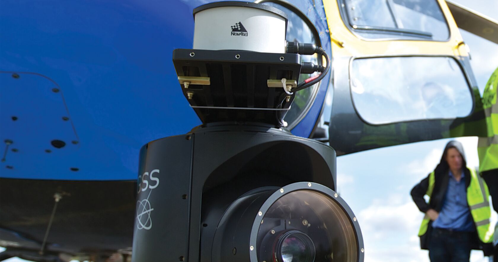
“OPTOnav operation relies on the principle of the software being told the precise location of the camera’s focal point and the target centroid pixel orientation with respect to the survey datum,” Forsberg says. “This requires a camera and GNSS receiver as a minimum and can go all the way up to a full inertial navigation system and stabilized camera turret.”
An aircraft or vehicle system can be custom-mounted in a stabilized turret such as the Gyro Stabilized Systems C516. The turret is instrumented with precision angular encoders and an externally mounted derivation of a NovAtel Synchronous Position, Attitude and Navigation (SPAN®) HG1900 Inertial Navigation System (INS).
Running through a combined Ethernet and RS422 link, imagery and navigation data is transmitted back to a Forsberg Services MICROpod-HDG. This houses two NovAtel GPS+GLONASS dual–frequency Real Time Kinematic (RTK) cards. The primary card is used to produce the INS data while the secondary card derives GNSS heading from a secondary antenna. Data is then taken from the NovAtel (SPAN®), GSS C516 turret, and Canon DSLR camera by MICROpod generated time-synchronisation pulses triggering data gathering from each component.
The HG1900 Inertial Measurement Unit (IMU) offers a hybrid package of Honeywell’s Micro Electromechanical Systems (MEMs) Gyros and RBA accelerometers. Economical, robust and small, the low power HG1900 provides high end tactical grade performance for commercial and military guidance and navigation applications. As a part of NovAtel’s SPAN GNSS+INS system, this IMU is ideal for airborne and ground applications that require accurate 3D position, velocity and attitude data.
A proprietary NovAtel MEMS Interface Card (MIC) couples the HG1900 IMU with SPAN receivers, offering a unique, powerful system for weight and size constrained applications. Designed as a board stack configuration for ease of integration, the MIC interfaces directly with NovAtel’s small form factor OEM615™ SPAN receiver.
The HG1900 is also available as a stand-alone product so integrators can easily pair it with an existing OEM6® SPAN receiver.
“Achieving best accuracy at the targets when moving at sixty knots needs millisecond level time-synchronization,” says Forsberg. “GNSS and INS synchronization are well known, and to a certain level so is camera synchronization. However, when you stray from the standard survey camera range, time synchronization has to be learned. For a surveyor on the ground the operation becomes simpler in that it’s enough to know the precise location of the camera and some ground reference points to orientate each image in space.”
For cameras, Forsberg has tended to go with digital SLRs. “They pack extensive capability into a compact size and can be enhanced with various prime lenses,” Forsberg says. “By example, we have used Canon 1DC, 1DX, 5D, 6D and 400D with 24mm, 50mm, 85mm, 300mm and 840mm prime lenses. Other cameras include the Nikon DSLR range and GoPro. All have their place and generally the more expensive the camera, the better the results.”
Overall accuracy achieved in real-time aerial survey is about 35 centimetres (two sigma) at ranges of 600 metres to the object. Using ground reference points, accuracy can be improved to a handful of centimetres. In particular, object mensuration is accurate to the centimetre level. For example, the gauge, gradient and camber of a railway can be measured from oblique images to within a couple of centimetres in length, a few hundredths of a degree in gradient and a few tenths of a degree in camber. The distance between measurement points dictates the angular accuracy. Also, precision is more dependent upon lighting conditions than pixel resolution.
The end-user could be a land surveyor on foot, in a vehicle or in an aircraft. “If on foot, we would equip the user with a portable computer such as PPM’s SKEYEBOOK,” Forsberg says. “This is in effect a Toshiba Toughbook with a built in NovAtel RTK receiver and antenna.
“Alternatively, for those who need a more compact unit, we can use a Tough Tablet with similar construction features. The OPTOnav software runs on that computer connected to a portable camera such as the Canon 5D and 24/50mm prime lens. The choice of lens depends very much on the range to the area of interest and required field of view.”
Forsberg Services also had to think about how the equipment would be aligned, installed and calibrated by personnel with no prior survey experience, such as aircraft engineers.
“In some ways, that has been more difficult than computing positions out of imagery,” Forsberg admits. For example, the inertial module is very particular about the orientation and offsets of peripheral equipment such as GNSS antennas from the IMU. Also, the camera and stabilized turret have to be boresighted to the INS too.
“If any part of this is wrong then the system will not achieve the required remote ground positioning accuracy of better than 50 centimetres (90%) at 500 metres,” says Forsberg. “That means offsets have to be measured to a couple of centimetres and angular alignments should generally be better than 0.025 degrees. The unique bit of this is completing the alignment within a few minutes while using actual survey imagery.”
Forsberg says the OPTOnav system had NovAtel components in it from the start. “The company relationship started with NovAtel in 1993,” he recalls, “when a fellow employee moved from a Houston-based company to NovAtel as a sales manager.
“Later, in 1996, we made an approach to NovAtel for the tracking of NASCAR and F1 vehicles for television. While this didn’t pan out as planned our company was contracted to run NovAtel Europe from about 1998. That continued until 2006. Today we are the dealer for NovAtel in the UK.”
As a result, Forsberg says, NovAtel technologies are extremely well known to his company at all levels, from engineering through to practical survey work and, of course, sales and customer support. “In particular we like their customer support. Customer Support has a reputation for speed and precision in answers.”
Forsberg says he and his team go to many shows and exhibitions, and they don’t see many real-time aerial survey systems. “What makes OPTOnav unique in that we can quickly coordinate points of interest and measure/orientate objects on the fly,” he says.
“Normally this type of data is gathered and post-processed, which can mean an extra day before the data emerges. For defense, when combined with other sensor technology, the application solves many latent problems.”
The GNSS module excels in accurate positioning, timing and inertial navigation. In particular, TerraStar-C corrections offer high levels of precision such that users can, generally speaking, achieve 3D position accuracies of 8-12 centimetres (RMS) on the camera.
And, Forsberg adds, there is a new upgraded version in the works, so this groundbreaking system is about to get even better.